


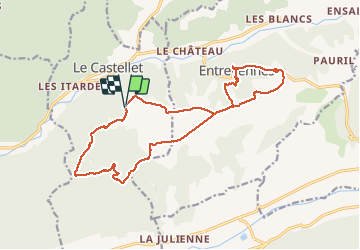
ENTREVENNES . TOUR DU COLOMBIER n

RobinMicheline
User GUIDE

Length
18.7 km

Max alt
691 m

Uphill gradient
347 m
Km-Effort
23 km

Min alt
501 m

Downhill gradient
347 m
Boucle
Yes
Creation date :
2021-01-18 07:59:43.006
Updated on :
2021-01-18 18:50:22.426
4h19
Difficulty : Medium

FREE GPS app for hiking
 SityTrail
IGN / Geographical institutes
SityTrail Plus
The world is yours!
About
Trail Walking of 18.7 km to be discovered at Provence-Alpes-Côte d'Azur, Alpes-de-Haute-Provence, Le Castellet. This trail is proposed by RobinMicheline.
Description
Long , pas trop de vue
Photos


Positioning
Country:
France
Region :
Provence-Alpes-Côte d'Azur
Department/Province :
Alpes-de-Haute-Provence
Municipality :
Le Castellet
Location:
Unknown
Start:(Dec)
Start:(UTM)
739629 ; 4868236 (31T) N.
Comments